Trail Walking La Ferté-Alais - La Ferté Alais (boucle par Boissy et la Pierre Levée) - Photo

La Ferté Alais (boucle par Boissy et la Pierre Levée)

 mmx007
mmx007

User

© OpenStreetMap contributors
Length
Length
24 km
Max alt
Max alt
153 m
Uphill gradient
Uphill gradient
311 m
Km-Effort
Km-Effort  
28 km
Min alt
Min alt
52 m
Downhill gradient
Downhill gradient
311 m
Boucle
Boucle
Yes
Creation date :
2016-03-11 00:00:00.0
Updated on :
2016-03-11 00:00:00.0

(0 Reviews)

Walking
Walking
6h04
Difficulty : Medium

Scan this QR Code to open this trail in the SityTrail application

FREE GPS app for hiking

Logo SityTrail SityTrail

IGN / Geographical institutes

Download SityTrail from the App Store Download SityTrail from Google Play

Logo SityTrail SityTrail World

The world is yours!

Download SityTrail from the App Store Download SityTrail from Google Play Download SityTrail on Huawei AppGallery

About

Trail Walking of 24 km to be discovered at Ile-de-France, Essonne, La Ferté-Alais. This trail is proposed by mmx007.

Description

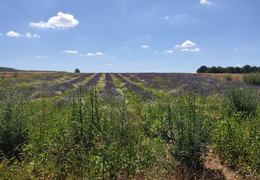
Boucle autour de la Ferté Alais, via Cerny, Boissy le Cuté, la petite mer de sable de Villeneuve-sur-Auvers, le Dolmen de la Pierre Levée de Janville, l'aérodrome de la Ferté Alais au loin et retour à la Ferté. RER D.
Balisage GR 111A, GR 1 et GR 11.
La difficulté de l'itinéraire (suivi en mai 2015) réside surtout dans sa longueur.
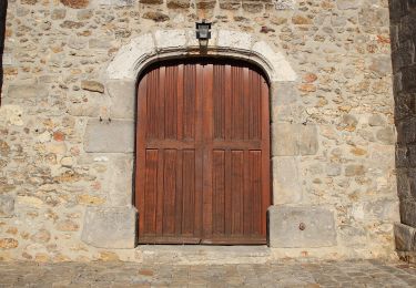
Voir les POIs pour plus d'informations sur les "choses à voir".

Elevation profile

Points of interest

Point of interest Cerny - 5 kms - Photo
mmx007
CERNY 
Point of interest Boissy-le-Cutté - Attention passage le long d'une route - Photo
mmx007
Point of interest Boissy-le-Cutté - Attention tourner à droite - Photo
mmx007
BOISSY-LE-CUTTÉ 
Point of interest Villeneuve-sur-Auvers - Attention balisage  - Photo
mmx007
VILLENEUVE-SUR-AUVERS 
Point of interest Villeneuve-sur-Auvers - Jonction avec le GR 655 Est - Photo
mmx007
VILLENEUVE-SUR-AUVERS 
Point of interest Villeneuve-sur-Auvers - 10  kms - Photo
mmx007
VILLENEUVE-SUR-AUVERS 
Point of interest Janville-sur-Juine - 15 kms - Photo
mmx007
JANVILLE-SUR-JUINE 
Point of interest Cerny - 20 kms - Photo
mmx007
CERNY 
Point of interest La Ferté-Alais - Eglise ND de l'Assomption - Photo
mmx007
LA FERTÉ-ALAIS 
Point of interest Janville-sur-Juine - Le Domen de la Pierre Levée - Photo
mmx007
JANVILLE-SUR-JUINE 

Positioning

Country:
France
Region :
Ile-de-France
Department/Province :
Essonne
Municipality :
La Ferté-Alais
Location:
Unknown
Start:(UTM)
452077 ; 5370390 (31U) N.

Trails nearby

Trail Walking Itteville - Les vieilles ailes - Photo
Walking
c.chehere

Walking

Easy
(1)
Itteville, Ile-de-France, Essonne, France
16.8 km | 19.2 km-effort
3h 37min
Yes
Trail Mountain bike Lardy - Autour de Lardy en VTT - Photo
Mountain bike
tracegps

Mountain bike

Medium
(1)
Lardy, Ile-de-France, Essonne, France
31 km | 38 km-effort
2h 4min
Yes
Trail On foot Itteville - Chemin des Marais - Photo
On foot
PRO

On foot

Easy
Itteville, Ile-de-France, Essonne, France
14.3 km | 16 km-effort
3h 38min
No
Trail Mountain bike Baulne - Les Marais de l'Essonne 29,5 km - Photo
Mountain bike
Bastet

Mountain bike

Easy
(1)
Baulne, Ile-de-France, Essonne, France
30 km | 33 km-effort
2h 12min
Yes
Trail Walking La Ferté-Alais - la ferté alais la sablière - Photo
Walking
mdsaintjalmes

Walking

Medium
(2)
La Ferté-Alais, Ile-de-France, Essonne, France
12.5 km | 14.8 km-effort
3h 15min
Yes
Trail Walking Mondeville - Boucle mondeville par videlles - Photo
Walking
Glurps

Walking

Very easy
(1)
Mondeville, Ile-de-France, Essonne, France
16.1 km | 18.6 km-effort
4h 2min
Yes
Trail Walking Ballancourt-sur-Essonne - V2foretxhospitalierexdexlaxcoudrayexballancourt-sur-essonne - Photo
Walking
philippevh

Walking

Medium
(1)
Ballancourt-sur-Essonne, Ile-de-France, Essonne, France
6.1 km | 7.9 km-effort
1h 47min
Yes
Trail Walking Bouville - Bouville - Photo
Walking
guydu41

Walking

Medium
Bouville, Ile-de-France, Essonne, France
8.4 km | 10.3 km-effort
2h 20min
Yes
Trail Walking Ballancourt-sur-Essonne - Ballancourt-sur-Essonne - Photo
Walking
guydu41

Walking

Medium
Ballancourt-sur-Essonne, Ile-de-France, Essonne, France
5.7 km | 7.4 km-effort
1h 41min
Yes


Close
My subscriptions